Document of the Month
Welcome to the Collection Showcase section of Warwickshire's Past Unlocked. On this page you can explore some of the interesting and important documents that we hold at Warwickshire County Record Office and learn about the historical background to their creation.
Each month we will highlight a different Document of the Month and display links to PDF copies of the previous 12 months documents for your enjoyment.
For earlier editions of Document of the Month, please see our archive.
Plan of ‘The Family Clump’
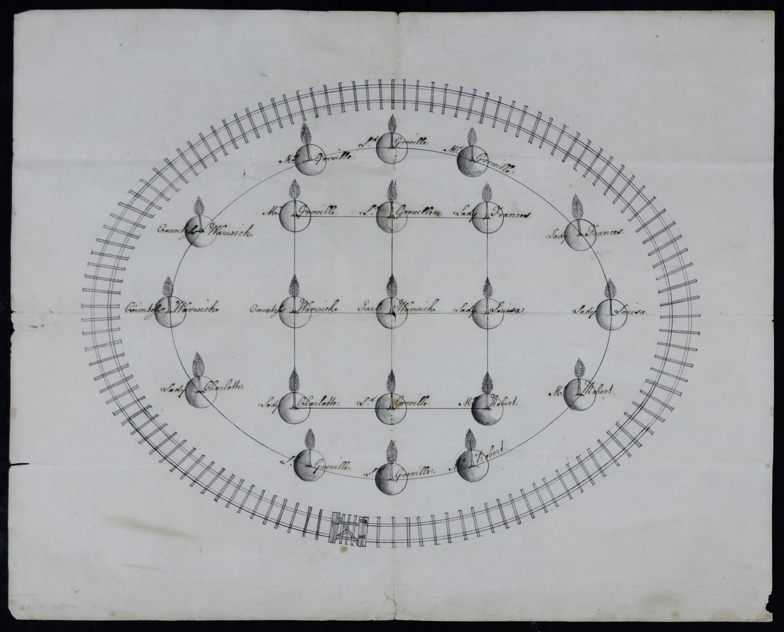
For April’s Document of the Month, we have chosen this 18th century layout plan for the planting of ‘The Family Clump’ of trees in Castle Park, Warwick. The plan can be found within the estate administration papers of the Greville Family of Warwick Castle collection (CR1886). The plan gives viewers today an insight into the new designs applied to the Warwick Castle grounds, which were redeveloped at this time.

Plan of ‘The Family Clump’
Warwickshire County Record Office, CR1886/Box 616/32
The document on display is an overhead view for a layout of a clump of trees planted in Castle Park, formerly known as Temple Park, which lay to the south of the castle. The drawing is made by hand using a pen on paper and features twenty-one shaded circles with a small drawing of a tree coming out of each. Nine of the trees are shown in the shape of a square in the centre, while the remaining twelve follow around the outside, in the shape of a circle. The trees are enclosed by a slated fence with access provided through a gate. The plan is given the name ‘The Family Clump’ as each tree is labelled with the name of a Greville family member, including Francis Greville, the Earl of Warwick (1719-1773) in the centre, his wife Elizabeth, the Countess of Warwick (1720-1800), and their children Louisa, Frances, Charlotte, George, Charles, Robert and Anne. The document is dated to 1759, due to the labelling of Francis Greville as the Earl of Warwick, a title bestowed on him by King George II in that year.
Unfortunately, we do not have the name of the person who drew the plan and there is no firm evidence that this clump of trees was planted. However, as we know that clumps of trees were specifically planted within Castle Park, the plan can give us an idea of how they would have looked.
Lancelot ‘Capability’ Brown
Following the death of his father in 1727, Francis Greville inherited the Warwick Castle estate and commissioned Lancelot ‘Capability’ Brown to re-landscape the castle grounds between 1749-1761. Brown, a famous 18th century landscaper, got his nickname from describing great country estates as having ‘capabilities’ for improvement. His designs incorporated country houses surrounded by woodland, parkland dotted with trees and carefully contoured grounds as well as serpentine lakes and architectural features such as follies, temples and bridges1.
The vision for Castle Park was that it was to be ‘enjoyed, not just from a static view from the castle but from a chaise drive around the park2’. Brown’s redesign therefore saw the creation of a scenic carriage track through the parkland, the construction of a dam at Ram Brook to make an artificial river, the addition of a timber bridge across the river Avon from Lodge Wood into Leafields3 and the undertaking of tree planting across the open parkland.
Tree clumps
Brown undertook extensive tree planting across the grounds. This included the planting of woodland along the boundaries of the estate and the planting of clumps of trees, like the document on display. Various castle receipts during the 1750’s show payments made for a variety of different trees. Receipts from 1750 show Thomas Webb was paid £1 5s for supplying ‘one hundred and twenty poplars4’, £20 was paid to Richard Wright for ‘one hundred quarters of lime’5 and there is also evidence for Scotch firs, Spanish chestnuts, Norway spruces and maples.
As shown in the plan of ‘The Family Clump’, newly planted trees were fenced off for protection from the deer in the park. There are numerous receipts in the castle accounts showing work to contain the tree clumps. For example, in 1750 John Bowson was paid £4 11s 7d ‘for setting the pails round the clumps6’ and £8 19s 10d was paid to Miles Kening for sawing ‘the clumps in the park7’. These fences required continual maintenance and there is evidence within the castle accounts of carpenters being paid to repair wooden posts, rails and gates specifically for the clumps of trees within the park.
The plan of ‘The Family Clump’, together with the evidence within the castle accounts, illustrate how important the planting and the maintaining of tree clumps were to the new vision for the landscape and how much wealthy landowners were willing to pay to transform their parkland.
References
- National Trust, ‘Who was Lancelot ‘Capability’ Brown?’ (accessed 20/03/25)
- Jacques, D. ‘Warwick Castle Grounds and Park 1743-60’ (accessed 20/03/25)
- Warwickshire Gardens Trust Journal Autumn 2007, Warwickshire County Record Office, F.WAR.(P)
- Warwick Estate vouchers, Warwickshire County Record Office, CR1886/400/5(iii)/bundle 9
- Warwick Estate vouchers, Warwickshire County Record Office, CR1886/400/5(iii)/bundle 9
- Warwick Estate vouchers, Warwickshire County Record Office, CR1886/400/5(iii)/bundle 9
- The accounts of Earl Brooke’s estates from 1756-57, Warwickshire County Record Office, CR1886/TN139
Please click on the links below to view PDF copies of previous Document of the Month articles (opens in new window)